Combining climate data with local knowledge for disaster preparedness
August 5, 2024 by
ISR Staff
Blog
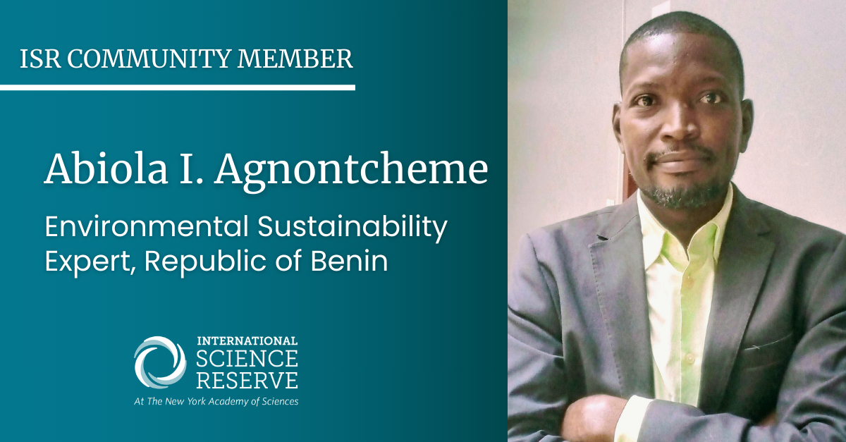
Abiola I. Agnontcheme is an environmental sustainability expert from Republic of Benin. He currently leads as the Country Director for Ecoclimate Vision Benin, which is a team of 40 national representatives with different backgrounds. Ecoclimate Benin partners with governments, businesses, and civil society organizations to collectively address the challenges of climate change worldwide.
He also works to translate climate change information from reputable sources into various languages spoken across the Global South. By providing localized content, Abiola can ensure that more people can access climate information in a language they understand, fostering greater awareness, engagement and contributing to community resilience.
Abiola recently spoke to the International Science Reserve about environmental risk management in the Global South, and how the ISR can be useful for increased cross-border collaboration on crisis.
You take climate data and information and translate it to Global South audiences. Can you tell us more about that process?
The information we share is sourced from reputable organizations, such as the UN Environmental Program (UNEP), the Intergovernmental Panel on Climate Change (IPCC), and the United Nations Framework on Climate Change (UNFCC). The information in English is shared via a Country WhatsApp Group which is translated in respective local languages. We shared quantitative and qualitative scientific data via community platforms and media to make it accessible to farmers, producers, and particularly vulnerable communities on the frontline of climate change impacts. We have also reached out online to our audience through social media sites like LinkedIn, Facebook and WhatsApp Group.
What are some of the challenges of not having localized and translated scientific data and information on climate change?
Ecoclimate Vision Benin works with more than 30 communities and partners in Benin. We do not always have the adequate vocabulary or specific words in local languages to make concepts clear for vulnerable communities within Ecoclimate Vision’s network. “Climate change,” for example, does not have an equivalent phrase when we are translating into a local language called Fongbe. The community who speaks Fongbe lives in southern Benin near River Oueme and many work in agriculture and fishing. Both industries are affected by the climate crisis.
Can you share more about your plans for community-based disaster risk reduction with governments, businesses and civil society?
We intend to collaborate with governments, businesses, and civil society organizations to design and implement climate change mitigation and adaptation projects. We are interested in flood resilience building and preparedness for our community which is the most frequently impacted by disasters in Benin; causing disruption within the community social system and disturbing livelihoods.
Why is it important to you do work with others outside your own discipline, country or region when it comes to disaster risk reduction?
Life is a learning process. I need to be open minded in learning new approaches that could be helpful for our vulnerable communities to sustain their livelihoods and continue supplying food and natural resources to our cities and markets. It’s beneficial to work with others to learn and gain expertise to use when disaster strikes in the world. Seasoned and well-prepared scientists can provide the meaningful expertise needed before and during a time of disaster.
Why did you join the International Science Reserve, and why would you encourage others to join?
I joined the ISR for the benefit of my country and community. We are one of the countries that is most exposed geographically to adverse climatic events, like flooding. which has caused long-term trauma; and disrupted food supply chains and environmental services. I also wanted to build my knowledge and expand my network on disasters to be prepared in advance. I would like to encourage others from any scientific sector in my region to join to learn and be useful for our community. The more people are prepared, the less harmful impacts there will be.
This ISR scientist uses e-noses to sniff out disasters before they happen
July 1, 2024 by
ISR Staff
Blog
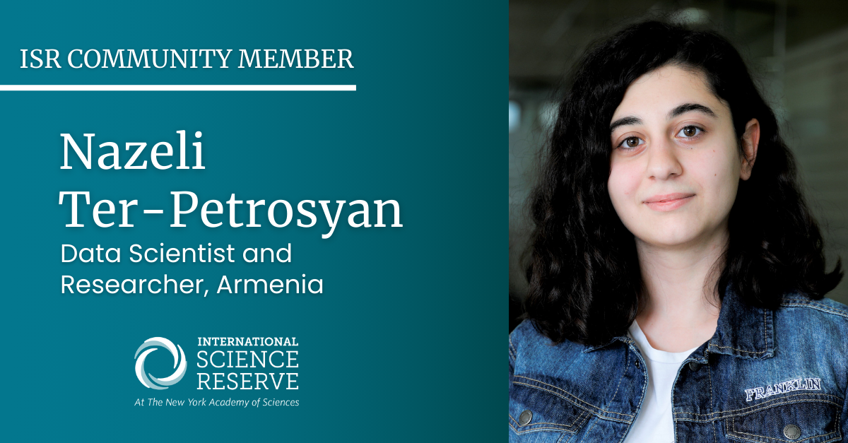
Nazeli Ter-Petrosyan is a data scientist and researcher from Armenia, researching artificial olfactory systems and biomedical image interpolation. She is a founding member and AI Developer at Wearify, a fashion-tech startup, and a data scientist at Opply, a food-tech startup optimizing the supply chain. As a TEDx speaker, young member of the New York Academy of Sciences, and a dedicated volunteer, she is passionate about contributing to and building community knowledge in her field.
Nazeli recently spoke to the International Science Reserve about the role of early career scientists in the initiative, and why she believes others should join her.
How do you envision using your data skillset and scientific interests to respond to crises?
One of my research projects focuses on artificial olfactory systems and their applications in various fields, including healthcare, environmental monitoring, and emergency and rescue services. Electronic noses (e-noses) can be used for the rapid detection of illnesses, monitoring emissions from oil and gas plants, and assisting rescue teams in hazardous environments such as fires. By researching this technology, I aim to contribute to developing tools that can support scientists and emergency professionals during crises.
Another research project I am working on involves biomedical image interpolation. Accurate interpolated images can provide scientists with videos at significantly higher frame rates, enabling the use of tools such as particle tracking for viruses. This can expedite the investigation of new viruses and their spread, ultimately accelerating the development of vaccines.
As an early-career scientist working in the private sector, what made you want to be part of the International Science Reserve?
The COVID-19 pandemic highlighted our lack of preparedness for efficiently managing a global crisis. When I learned about the ISR’s mission to create a global community of scientists ready to respond to various crises, I wanted to be involved. I believe that the initial response and preparedness are crucial in dealing with crises.
By participating in simulations and projects, scientists can develop plans for different scenarios, making it easier and faster to implement these plans when an actual crisis occurs.
How do you hope to contribute to the ISR and crisis response?
I hope to contribute to the ISR by participating in various exercises and discussions with community members. I am eager to collaborate with them to build new solutions and refine existing technologies that can be helpful during emergencies. In the future, I would also love to help organize and develop crisis response plans.
Why should others join the ISR, particularly young scientists?
A major reason to join the ISR is the opportunity to become part of a global network of scientists. The ISR community includes individuals from diverse backgrounds, ages, and career stages, providing a rich environment for growth and learning.
Interacting with scientists worldwide offers invaluable perspectives and insights. Additionally, participating in ISR’s exercises allows you to deepen your knowledge in your chosen field and refine your critical thinking and rapid-response skills.
How one Mozambican researcher hopes to mitigate the climate crisis through coffee
May 28, 2024 by
ISR Staff
Blog
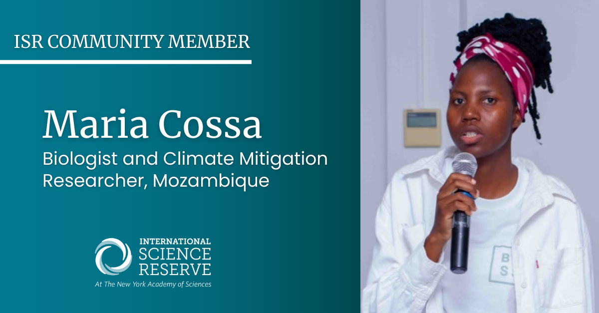
Maria Tomas Cossa is a marine biology graduate with a Master’s in Conservation Biology. She is a member of the International Science Reserve and a prominent researcher at Mozambique’s Bazaruto Center for Scientific Studies.
Currently, she is working on climate change mitigation through her pioneering research on coffee agroforestry systems and looking into the potential to store carbon in the soil. Maria’s commitment to sustainability and problem-solving on climate change is not just a professional pursuit, but also a personal passion.
Maria recently spoke to our team about why she joined the International Science Reserve, and the role she believes scientists can play in her region to help prepare for climate-related disasters.
What inspired you to study biology, and specifically climate change mitigation?
As I grew up in Mozambique, I became increasingly aware of the pressing issues facing our planet, particularly the rapid changes occurring in our climate due to human-induced factors such as greenhouse gas emissions, deforestation, and pollution. For example, the average temperatures in Mozambique have increased 1.5 – 2⁰C between 1961 and 2010. With this, we face so many storms nowadays that destroy the coast and ecosystems such as dunes, seagrass, coral reefs and mangroves. The realization that our actions were driving significant shifts in ecosystems, leading to biodiversity loss, extreme weather events, and disruptions in global patterns, deeply troubled me.
Moreover, the urgency of climate change and its profound implications for future generations. This motivated me to actively seek ways to contribute to mitigation efforts. Whether through research, education, advocacy, or practical interventions, I felt compelled to make a positive impact and help foster a more sustainable relationship between humanity and the planet.
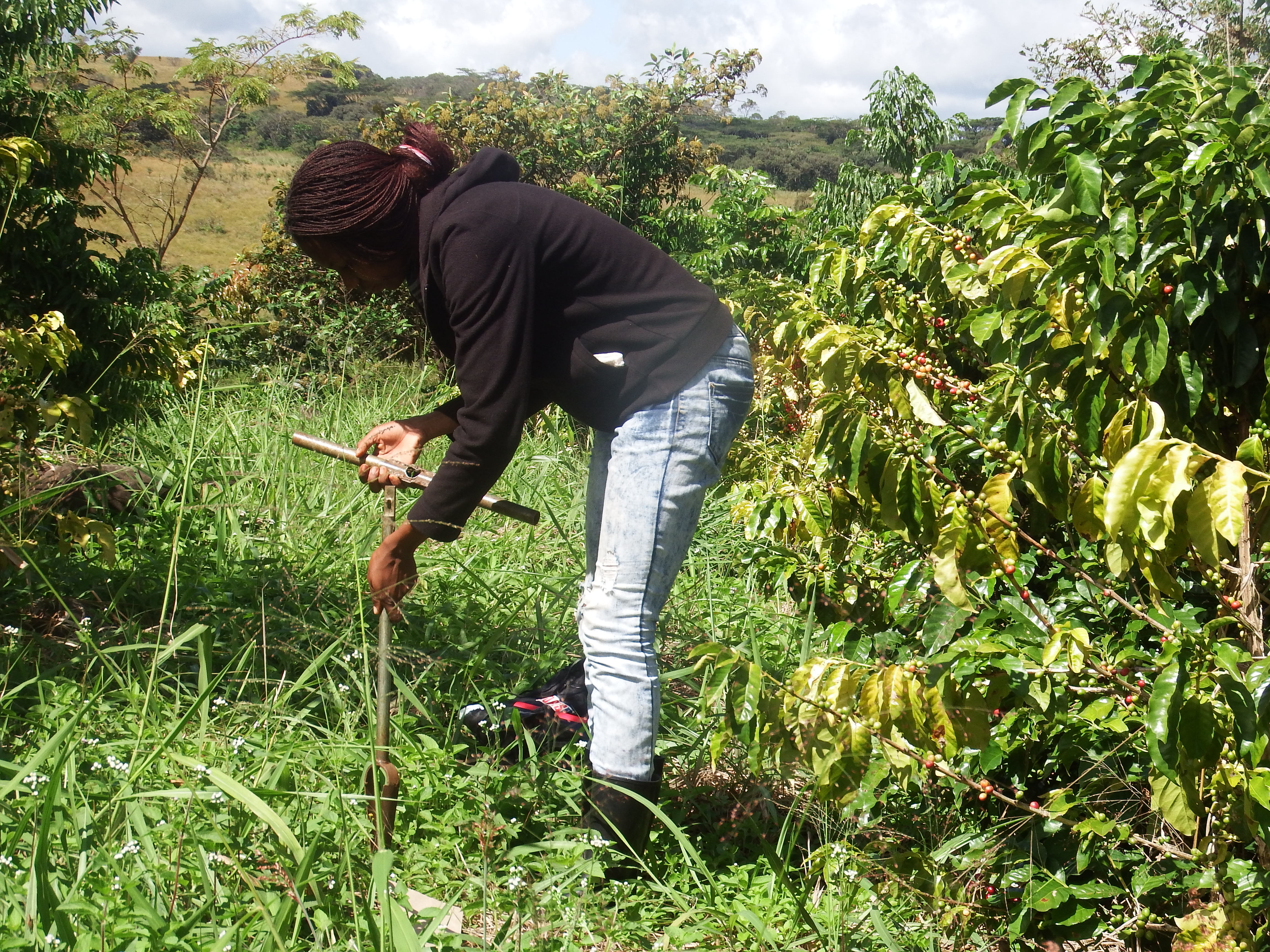
ISR community member Maria Cossa studies coffee agroforestry (Photo Courtesy of Maria Cossa)
Tell us a little more about your pioneering research on coffee agroforestry and carbon sequestration.
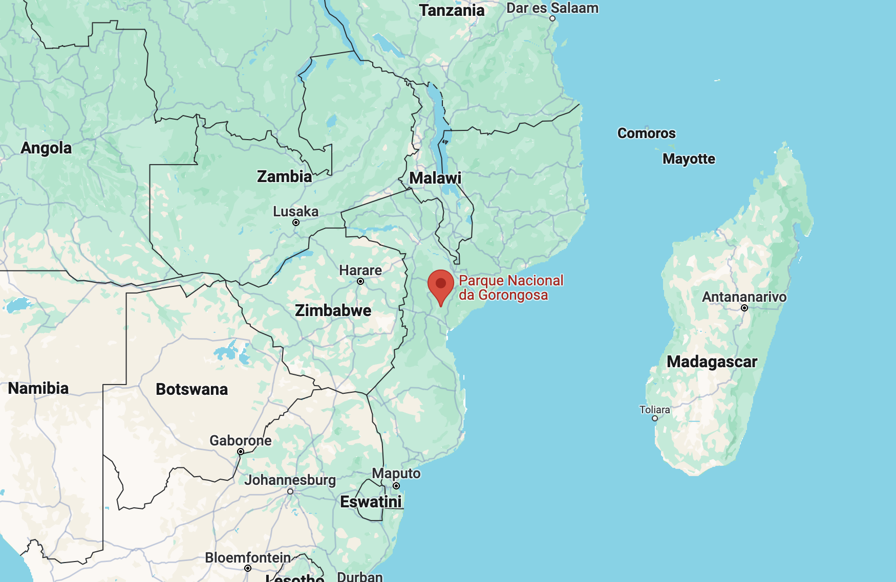
In Mozambique, the tropical Afromontane forest of Mount Gorongosa in Gorongosa National Park is home to coffee agroforestry systems that were developed specifically to contribute to agriculture, restoration, and climate change mitigation. In my research, I am working to gain a better understanding of the carbon storage capacity of soils in coffee agroforestry systems, and particularly how planting coffee with native tree species will help develop methods that support these climate benefits.
Mount Gorongosa contains fragments of natural forest alongside fallow agricultural land and a restoration program using shade-grown coffee. Coffee has been planted under native shade trees since 2014, and as the coffee ages out of production, the land will be left with a well-developed canopy of native species.
This is the first shade grown coffee project in Mozambique, and before this study, there were no data on carbon stocks on Mount Gorongosa. The main objective of the research was to study the contribution of coffee agroforestry systems on Mount Gorongosa to the soil’s carbon storage.
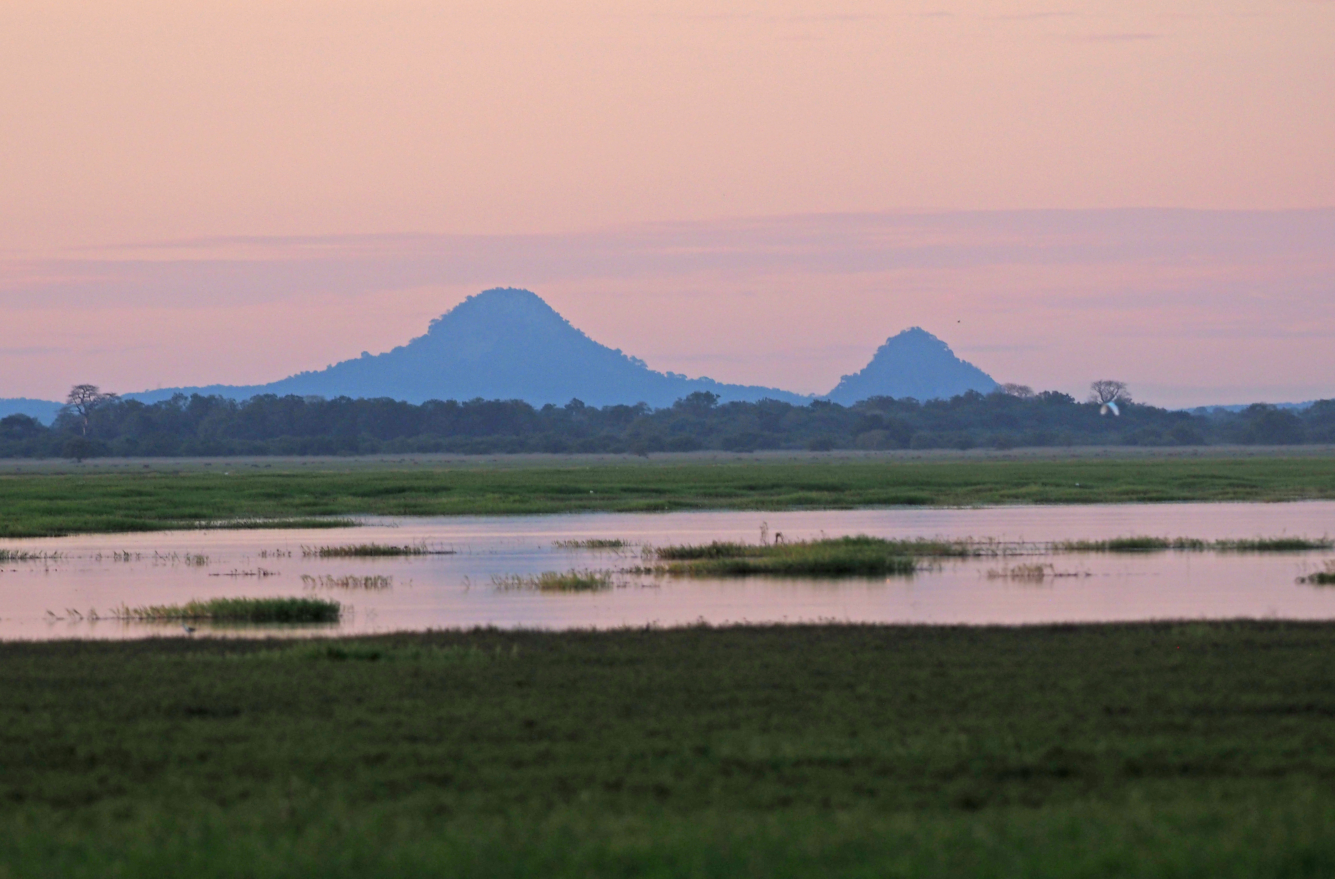
Gorongosa National Park in Mozambique
What inspired you to join the ISR? Why should more researchers from your region join the ISR?
I joined with the intention of connecting with other national and international scientists and researchers who have been working towards the conservation of biodiversity. In my country, we lack a lot of data that can help in decision making and being in such a wide network of researchers can open up opportunities for collaboration.
What role can biologists play in helping us all better prepare for and respond to climate-related disasters?
Biologists can play a multifaceted role in helping better prepare for and respond to climate-related disasters by contributing scientific knowledge, monitoring ecosystems and biodiversity, developing early warning systems, assessing risks and vulnerabilities, and informing policy and management decisions. Through collaborative efforts and a deep understanding of ecological processes, biologists can contribute to building more resilient and sustainable communities in the face of climate change.
What gives you hope or motivation to keep doing your work, given all the challenges we face today on climate change?
What motivates me is the fact that I know that there is still some hope of reversing the current situation on our planet, although there are many challenges. I have also seen cases of success in changing attitudes and that encourages me a lot.
For example, here in Mozambique we have mangrove and seagrass restoration projects where communities are the key elements and lead these projects, a large part of the mangrove is being recovered and with that other ecosystem services and various fishing resources that are of extreme importance for the coastal communities. This success story encourages me to continue this fight involving all sectors, from community to government.
“Did you feel it?” How understanding small earthquakes readies us for big ones
May 6, 2024 by
ISR Staff
Blog
Sarah Minson is a Research Geophysicist with the U.S. Geological Survey Earthquake Hazards Program. Sarah’s research attempts to understand not only how faults slip, but also to understand what we can and cannot determine about earthquake ruptures and how these uncertainties affect our estimates of potential earthquake impacts. She has also studied earthquake early warning systems to determine what kinds of warning are possible, and what kind of accuracy can be achieved.
Sarah recently joined an ISR webinar about earthquake preparedness, and then spoke to our team about how we can apply lessons from earthquakes across crisis preparedness efforts.
In early 2024, earthquakes struck Japan, Taiwan, and the United States. How did they fare in terms of being prepared for disaster?
Japan, Taiwan, and the United States all have high building standards and strong earthquake preparedness programs, which can help mitigate infrastructure damage and reduce casualties, but these are still traumatic events. Our hearts go out to everyone who was impacted by these earthquakes.
The Japan and Taiwan earthquakes were much larger magnitude events, causing strong shaking and significant damage. Both Japan and Taiwan have earthquake early warning systems, although the performance of the systems differed significantly. Because these earthquakes were located along the coast, causing seafloor deformation, they both led to tsunamis. There were tsunami warnings and evacuations immediately following each earthquake. In both events, landslides and rockfalls triggered by the earthquake shaking produced significant damage. These earthquakes were devastating, and their impacts will be felt for a while, but the high degree of preparedness in both Japan and Taiwan, as well as their earthquake and tsunami warning systems, helped to mitigate the impacts.
The United States is also highly prepared with earthquake and tsunami warning systems. The New Jersey earthquake was a smaller magnitude event that was onshore. Therefore, it could not trigger a tsunami, so these systems did not come into play. The most significant impact of the New Jersey earthquake was probably how many people felt the shaking.
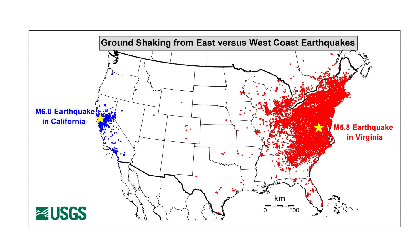
One thing of note about the central and eastern United States is that shaking amplitudes decay very slowly with distance from the earthquake compared to the western United States. This is, in part, because there are so few earthquake faults. The rock is strong and intact. Thus, a huge region — and a huge number of people — can feel shaking from even a relatively small magnitude earthquake like this one.
After any earthquake, we encourage people to visit our website for earthquake information and to report whether they did (or did not) feel shaking. These observations are very valuable and help us understand how shaking from earthquakes varies. We received a record almost 184,000 “Did You Feel It?” reports for the New Jersey earthquake. It is the largest number of responses to “Did You Feel It?” for a single event since the program began in 1999 and broke the previous record of 140,000 responses for the 2011 M5.8 Mineral, Virginia earthquake (another eastern U.S. earthquake).
Can you share more about your research into early warning systems?
The first thing to know about earthquake early warning is that the name is terrible. It is not an earthquake warning. Instead, we monitor earthquakes as their ruptures evolve and warn people (and trigger automated protection systems) before the shaking from the earthquake arrives at their location.
The most familiar measure of an earthquake is magnitude, which is a single and simple number that literally describes the physical size of an earthquake rupture. Magnitude is the length of the earthquake rupture, multiplied by the width of the rupture, multiplied by how far one side of the fault slid relative to the other side. Then the result is converted to a logarithmic scale.
However, the shaking from an earthquake is highly variable and will not be the same for everyone. Shaking intensity decreases with distance from the earthquake, but can be amplified or deamplified by the type of soil you are standing on (hard rock or soft soil), your relationship to the dynamic evolution of the earthquake (whether it is rupturing towards you or away from you), and your personal situation (for example, whether you are on the ground floor or top floor of a building).
The single thing that most affects earthquake early warning accuracy is our ability to forecast what the shaking will be at your location. But even if our shaking models were perfect, there would still be accuracy and time limitations because earthquakes are not instantaneous: their ruptures evolve over seconds (for small magnitude earthquakes) to minutes (for large magnitude earthquakes).
If we were to wait for an earthquake to conclude so that we can make our best possible shaking forecast, we would use up all the warning time before the shaking arrived at your location. So, earthquake early warning must always be to some extent precautionary: we are alerting you to an earthquake in progress that has the potential to continue evolving into something that could cause significant shaking at your location.
During the ISR’s recent webinar on earthquakes, you spoke about scientists working with structural engineers and building designers to design buildings with earthquake science in mind. Why is cross-sector collaboration important in a crisis?
The U.S. Geological Survey’s mission is to serve the Nation by providing reliable scientific information to describe and understand the Earth. One of our most important products is a national seismic hazard model that forecasts the intensity and frequency of earthquake shaking everywhere in the country. This is the information that can determine to what strength of shaking infrastructure must be resilient. That is, what level of shaking must a building be able to withstand for it to be safe. But how safe is safe? How unlikely and infrequent an earthquake is sufficiently unlikely and infrequent when it comes to earthquake risk?
These questions must be answered by people and their representatives in conversation with structural engineers and designers, balancing not just earthquake hazard considerations but all sorts of other hazards and societal needs and risks. What earthquake scientists can and do provide is scientific analysis so that people can make informed decisions.
You also spoke about planning ahead and prioritizing the safety of people with disabilities during disasters. Can you share your best practices?
In the webinar, Yuichi Ono, director of the International Research Institute of Disaster Science at Tohoku University, gave a very informative overview of some of the difficulties that were encountered in the aftermath of the January 1, 2024, M7.5 Noto Peninsula, Japan earthquake, and the special risks faced by those who are older or disabled. In the United States, where earthquakes are relatively infrequent and we may not have personal memory of a damaging earthquake, we can look to our recent experiences with other sorts of natural disasters, such as wildfires and hurricanes, to see how evacuations and recovery can be more or less difficult based on people’s individual circumstances and physical abilities.
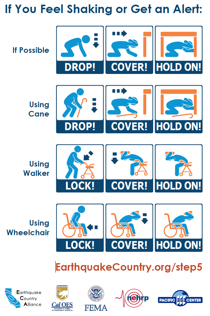
One thing that is unusual about earthquakes relative to many other natural disasters is that they do not require evacuation, although tsunamis resulting from earthquakes can require immediate evacuation. Instead, in the United States where buildings are built to a life safety standard and should not collapse during an earthquake, the protective action that everyone should take when they feel earthquake shaking (or receive an alert from an earthquake early warning system that shaking is imminent) is drop, cover, and hold on to protect themselves from falling or being struck by something.
This protective action can be adapted to everyone’s individual mobility. The U.S. Geological Survey through the National Earthquake Hazards Reduction Program (NEHRP) as well as governmental and non-governmental science, preparedness, and emergency response organizations are all working to make earthquake preparedness accessible to all.
What steps should you take if you feel an earthquake or get an early warning?
There are three things I personally would like everyone to know about earthquakes. One is how to protect yourself. As we just discussed, if you ever feel shaking or get a warning: drop, cover, and hold on to protect yourself.
The second thing is that earthquakes are not magic. Earthquakes obey simple laws of physics: a point on a fault is stressed, it moves, it transfers stress to the surrounding parts of the faults; if those parts of the faults are sufficiently stressed, they move too; and the more parts of the fault that move the larger the earthquake.
The problem is that we get to observe none of this. These faults are moving miles underground where we have no direct observations of the stress on the fault or the material of the fault interface or whether it is lubricated by fluids or glued together by small-scale fault structures. All we can do is observe how the surface of the Earth deforms in response to what is happening at depth and attempt to infer what is happening on the fault. This is what limits our ability to tell you what is happening on the fault right now, or what will happen in the future. This is why we cannot predict earthquakes. It is not because we do not understand earthquake physics (we do) and it is not because earthquakes are magic (they are not magic).
Lastly, I personally would like everyone to know that the largest source of earthquake hazard is not “The Big One” – an infrequent large magnitude earthquake. The bigger hazard is the medium ones. While each of these more moderate magnitude earthquakes impact a smaller area (again, magnitude literally comes from the length of an earthquake rupture) and usually have less intense shaking, they sometimes produce strong shaking, and they happen much more frequently than large magnitude earthquakes.
Why does this matter? When people focus on The Big One like a M8 earthquake that happens only every few hundred years, they may feel fatalistic: why prepare for something that is so rare and so scary? But if instead you focus on the more common earthquakes that happen year in and year out, the kinds of earthquake that you might even have lived experience with, the kind of earthquake that you are actually most likely to have to deal with, then you can be confident about being prepared for an earthquake.
Visit https://www.ready.gov/earthquakes for easy preparedness steps you can take. If you feel shaking, drop, cover and hold on. Have a plan for your family. Put your grandma’s dishes somewhere safe so that they do not fall off a shelf in the shaking from a moderate magnitude earthquake. These things are doable. These things can keep you and your family (and grandma’s dishes) safe.
Why this weather man wants to break down silos in climate and crisis research
March 6, 2024 by
ISR Staff
Blog
As a climate scientist and meteorologist, Dr. Anthony Torres has dedicated his career to researching, teaching, and forecasting climate change and extreme weather. Most recently, he worked with Currently, a startup that provides timely and actionable weather forecasts in 20 cities.
Dr. Torres’ academic research on understanding what drives the behavior of carbon dioxide (CO2) measurements from space has been supported by NASA and gave scientists another way to better understand how much CO2 remains in the atmosphere through 2100. His groundbreaking research also helps climate scientists model how global temperatures might change under various emission scenarios.
Dr. Torres recently spoke to the ISR team about the role of meteorologists in working across silos and preparing the public for climate-related crises and disasters.
How did you get into climate science and meteorology?
As a child, I vividly remember being in a tornado outbreak. I spent the day in the pool until the massive storm clouds came rolling in. By the time we closed the pool, the tornado sirens started blaring and we ran to seek shelter in our house. Soon after, winds in excess of 100 mph wreaked havoc in the area. It turned out multiple tornadoes had also touched down nearby. I remember all of the shattered windows, downed trees, blown lawn furniture, and damaged buildings after the storm.
It was the first time I witnessed the extreme power of nature and I wanted to know more about it. Afterwards, I acquired all kinds of weather books, would watch The Weather Channel, and had my own miniature weather station.
What strategies can experts in the meteorology field use to help better prepare for and respond to climate-related disasters?
There are multiple fronts in which we can improve our preparation for disasters:
First, we need to close the gaps in observations. The US and Europe have dense networks of observations that allow for early detection of weather systems. Even here, gaps in detection networks, such as radar networks in the US, create challenges for detecting tornadoes or other severe weather events. In the Global South, where the density of weather observations is sparser, it is even more challenging to forecast extreme weather events. By closing these gaps, we can better monitor extreme weather events before they happen — giving us the chance to provide adequate warning to everyone affected.
Second, meteorologists need to be more interdisciplinary. While meteorology is a physical science, the impacts from meteorological events are not. The most accurate weather forecast is only as good as how it has been received by its intended audience. Communication is key. We need to work with all of our stakeholders, as well as leverage the expertise of social scientists and disaster experts to build a shared language so that we can maximize the number of people that receive adequate warning of incoming hazards.
What advice do you have to break down boundaries as scientists who care about crisis preparedness?
First, incentivize interdisciplinary interactions. Meteorologists — especially on television — historically have been “general practitioners” of science as science directors at their respective stations. However, we are only formally trained in a narrow subset of science. This has led to the spread of misleading information, which has real consequences. We need to understand appropriate limits of our own expertise and when to defer to others and ensure that everyone is informed with the best information possible based on the best science available.
Second, build channels with communities affected. Often communication is delivered in a top-down method with few channels for bottom-up communication. Social media has helped level conversations in some ways, but it has not nearly gone far enough. Go into these communities with the intent to learn about what is important to them, and how to build effective communication strategies in advance of a potential crisis. Recognize that these communities are not monolithic and that there is no “one size fits all” solution for crisis preparation.
Finally, incentivize stewardship of our disciplines. The careers of scientists are often rewarded by research and publication metrics with a baseline expectation of service work. By shifting the paradigm to weighing service with respect to broader impacts and reaching out to local communities more heavily, we deconstruct the silos built up by the ivory tower.
Meteorologists play a very important role in communicating climate science to the public. What advice do you have?
Despite any narrative to the contrary, my experience has been that most people genuinely crave access to science knowledge. Anytime someone asks what I do, the conversation shifts to weather and/or climate. Use this as an opportunity to relight the passion that got you into science and share that enthusiasm with the people you meet.
Like any speaking engagement, it is important to know and be comfortable with your audience. An awkward conversation or talk is still awkward, regardless of the topic. Find common ground. Remove as many barriers as you can to maximize the connection you make with your audience.
What gives you hope or motivation to keep doing your work, given all the challenges we face today on climate?
Every bit of progress we make counts and makes a difference. The more we limit our planet’s warming, the less we will need to deal with climate changes and extreme weather patterns. The more we are prepared for the next disaster, the less dire the consequences. I remain optimistic humanity will learn these lessons and set forth a path to a better future.
ISR community member Daniel San Martin from Chile on wildfire prevention
November 28, 2023 by
ISR Staff
Blog
In any major climate-related crisis, access to geo-spatial-temporal datasets, mapping, modeling, and analytical tools are critical to aid recovery efforts and protect communities. Many expert researchers, especially scientists and institutions in low-to-middle income countries, lack the tools to access and analyze relevant data, to inform local decision makers on how to act rapidly and effectively.
During a recent panel with the Predictive Analytics World (PAW) climate conference, we spoke with ISR community member Daniel San Martin of Universidad Técnica Federico Santa María in Chile. Daniel specializes in scientific computing with a current research focus on computational fluid dynamics, numerical methods, and high-performance computing applied to forest fire modeling.
How are you using data to inform crisis preparedness and decision-making on wildfires in your region?
Our work is not only based on data, but we also use physical models and simulations to get or evaluate dangerous zones and vulnerable locations. Our approach is to use these simulations to make informed decisions for experts in disaster management, like government institutions. We can also use the models to create new data for AI-based models in order to complement the analysis. The main contribution of our work with wildfires is trying to best inform the people who make the decisions and try to minimize the damage of wildfires.
Why did you look for collaborations outside of Chile, and why is a global network like the ISR beneficial to your work?
I think collaboration with a global network is crucial for developing countries, like Chile. We do this to tap into diverse expertise and to gain a global perspective, specifically on disasters. Also, to share resources and build capacity for rapid response. I think different experts in disaster management approach this work in order to help shape policies. I strongly believe that global collaboration is mandatory nowadays to face any kind of disaster, even more so now that we are suffering the effects of climate change.
How does access to resources, like geospatial mapping and modeling, impact your research and work?
In terms of data, it is really tricky in my region because of the availability of the technology or the funding to get intelligent data, like they have in the United States. We have a lot of resource constraints, such as spatiotemporal resolution issues, data integration complexities, sharing restrictions, data quality concerns, resource constraints, and remote sensing limitations, among others. We usually try to use the data provided by US or European institutions. We use that data to create models, but it cannot always be applied because we have geographical or meteorological differences. We need data and tech development by other countries, to create or adjust the tools to our own context.
What more could be done for researchers like yourself to get the data you need, and communicate it to decision makers?
To better support researchers in disasters, enhanced data accessibility through open initiatives and real-time streams is crucial. This includes advocating for standardized formats and integrating advanced remote sensing technologies. To communicate findings effectively to decision makers, user-friendly visualization tools and comprehensive scenario analysis reports are essential. Collaborative engagement with stakeholders, including regular workshops and educational initiatives, can bridge the gap between researchers and decision-makers, fostering understanding and trust.
Additionally, advocating for policy integration and offering training sessions to decision makers can ensure that scientific research is considered in disaster management strategies, ultimately enhancing the impact of simulation models on informed decision-making.
Researchers are invited to join our science community - a borderless global network of leading scientists from around the world. Join the community today to stay updated and learn how you can participate.
As part of The New York Academy of Sciences, the International Science Reserve offers a network of open scientific communities, bringing together specialized resources from across the globe to prepare for and help mitigate complex and urgent global crises. We focus solely on preparing and mobilizing scientists to augment existing response organizations.