Before Hazards Become Disasters with Blavatnik Award Winner Dr. Elaina J. Sutley
by ISR Staff
Dr. Elaina J. Sutley is an Associate Dean for Impact and Belonging, and an Associate Professor of Civil, Environmental, and Architectural Engineering at the University of Kansas, USA.
In 2025, Dr. Sutley won the Blavatnik Award for Young Scientists for her groundbreaking work on comprehensive, systematic computer modeling and engineering to address disaster mitigation and recovery. Her work informs building codes and disaster readiness policies across the United States.
Dr. Sutley recently spoke with the International Science Reserve about her research.
Congratulations on the Blavatnik Award! Can you share how this will help you advance your research on designing disaster prevention strategies?
Thank you! I am so honored to receive this award, and particularly grateful for the attention and recognition it will give to natural hazards and disaster research. The award opens up a new network that I’m eager to build connections with and explore new ways to help communities prevent hazards from becoming disasters.
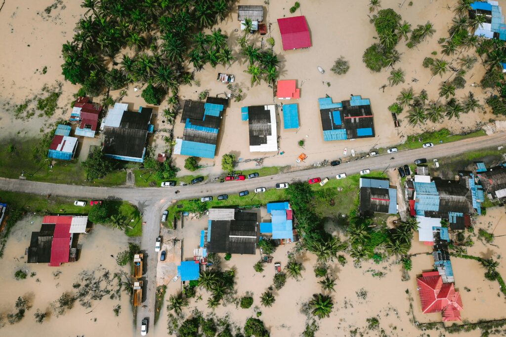
As an engineer, you approach your research through an interdisciplinary lens, examining not only how we design buildings, but also the social implications of disasters like floods and wildfires in communities over time. What makes this approach more effective, in your opinion?
I’m so grateful that during my PhD, I was co-trained in sociology which helps place people at the heart of what I do as an engineer. Placing people front and center has driven my research in directions that can result in a huge impact. For example, because we were focused on the disparate long-term experiences of people after disasters, we were able to highlight an otherwise invisible outcome of child homelessness. We developed a model that estimates child homelessness after disasters and even mapped these to school districts. The model is incorporated into a decision-making tool used by real communities in the U.S. so when these decision-makers are determining whether or not to invest in a mitigation strategy, they can see this long-term human impact that could be reduced or even prevented by the investment.
Additionally, I’ve built a fairly significant body of work focused on improving the performance of manufactured homes during disasters. While there is much more work left to do here, I was able to successfully change FEMA’s Direct Housing Guide so that now disaster victims can still receive these otherwise rapidly distributable homes, but in a safer way. This type of structure is particularly important because, as the most common type of unsubsidized affordable housing in the US, it provides critical shelter to an often-overlooked segment of the population. Working from an exclusively engineering lens, these are non-engineered structures and may be considered outside of a structural engineer’s scope of work. But because of who lives in them, they became a critical focus for my research group.
By studying the impact of tornadoes on manufactured housing or other structurally weak building designs, you are baking equity into your research approach. What experiences made this important to you?
There are perhaps two seminal experiences I’ll point to. The first is when I was a graduate student at the University of Alabama when a superstorm of tornadoes came through creating devastation across the city in 2011. The damage was disparate, and so was the recovery process. It was the first time I came to understand how differential access could really change a person’s quality of life.
Then in 2015, I had the wonderful opportunity to be part of the NIST-funded Center for Risk Based Community Resilience Planning. This 10-year project included a longitudinal field study in Lumberton, North Carolina, which I led starting in 2016. Our team went to Lumberton 9 times to collect data on damage and impact, decision-making, rebuilding and recovery over the course of 7 years. We surveyed the same households repeatedly through this process to document their experiences. It was a profound experience for me that truly highlighted the immediate and long-term inequities of disasters and further enhanced my commitment to center people and equity in my research.
What advice do you have for other young scientists or engineers who want to translate their research into policy? For example, do you have tips for working with government and policymakers on disaster or crisis prevention?
Do it! We need more scientists and engineers communicating and translating their work into policy and practice.
I’ll share two tips. First and with most new relationships, I find it is always important to listen first. When you are working with government and policymakers, or even building codes – there is a process, there is a procedure, and there are constraints. Figure those out. Be known as someone who will listen and learn and then work within the system. Second, channel your inner resilient optimist. Look for reasons something can work – not for reasons it won’t. Look for solutions and paths forward, and don’t give up. This positive energy will rub off on others, and they’ll be more willing to help you figure it out and connect you with the people they know, and it’ll give you some ideas for how to accomplish your goals by illuminating the path forward.
Given the ISR is a global network, are you working with researchers across borders – and why is that valuable?
Absolutely! And there is so much we can learn from working across borders. In the past, I’ve worked on a project that was focused on the seismic hazard in Nepal. Presently, I am collaborating with researchers based in Canada and Indonesia on retreating from risk through strategic retreat / community relocation mechanisms. There are socio-political, technological, and hazard-specific reasons that make it where not everything we do is applicable everywhere. But in general, the problems we face are not exclusive, and there are brilliant and dedicated people around the world that we can learn from and that we can share our insights with so that together, we can all reach higher levels of innovation that support the betterment of society.